
General Description
| UN/LOCODE: | RUPRI |
| Port Coordinates: | 60° 20′ 5″ N, 28° 43′ 0″ E |
| B. A. Nautical Chart No: | 2393 – Primorsk Oil Terminal and Approaches 2264 – Gulf of Finland – Eastern Part Publication 2817 – Baltic Sea – Northern Sheet and Gulf of Finland |
| Admiralty Sailing Directions: | NP 20 |
| Time zone: | UTC +3 hrs |
| Port Security Level: | 1 |
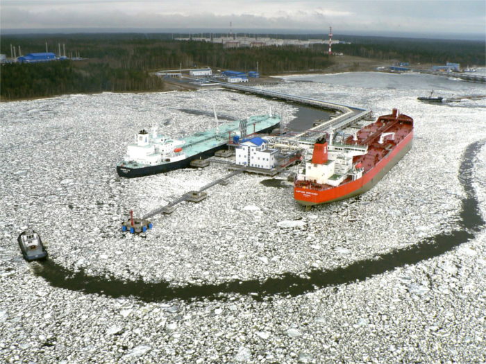
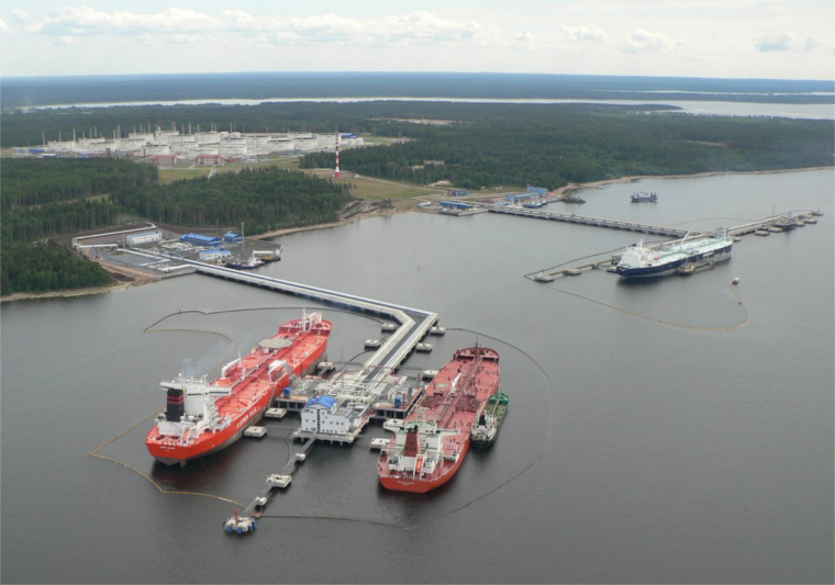
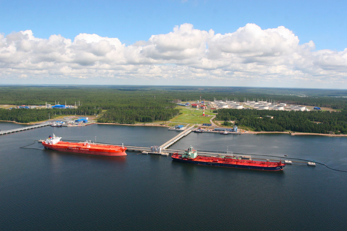
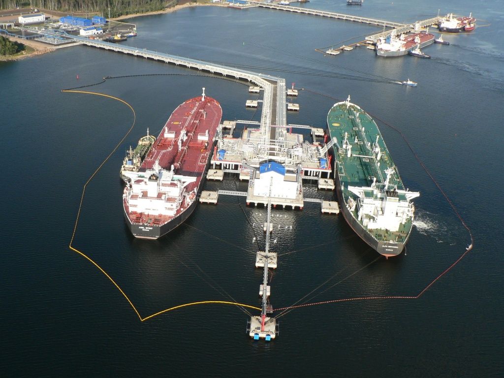
Primorsk Port is located in the strait of Björkösund, about 120 km to the North-East of St. Petersburg. The port came into operation on 28 December 2001. There are six operational berths – berths # 1 & 2 are for loading Crude Oil and berths # 8 & 9 are for loading Oil Products, while berths # 3 & 4 are for loading both Crude Oil and Oil Products. Shore tanks with a total volume of 500.000 tons for crude oil and 240.000 tons for diesel oil are available. The maximum designated capacity of the crude oil terminal is 75 million tons per year and for diesel oil terminal the figure is 20 million tons per year. Maximum loading rate of the crude oil terminal is 10.000 cbm per hour. Maximum loading rate of the Oil Products (Diesel Oil) is 2.800-3.300 cbm per hour depending on the tanker tonnage and number of loading arms connected.
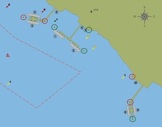
Anchorage Areas
Sea port anchorages are limited by straight lines connecting points enclosed by position:
Anchorage No 6 (min depth 14.4 meters, bottom – silt, sand):
No 1 – 60° 20’ 60” N, 028° 40’ 50” E
No 2 – 60° 20’ 00” N, 028° 41’ 57” E
No 3 – 60° 19’ 60” N, 028° 43’ 00” E
No 4 – 60° 19’ 24” N, 028° 41’ 95” E
No 5 – 60° 20’ 30” N, 028° 39’ 60” E
Anchorage No 6а (min depth 21.4 meters, bottom – silt, sand):
No 1 – 60°18’ 00” N, 028° 44’ 77” E
No 2 – 60° 18’ 43” N, 028° 44’ 42” E
No 3 – 60° 18’ 43” N, 028° 45’ 17” E
No 4 – 60° 18’ 00” N, 028° 45’ 68” E
Anchorage No 10 (min depth 15 meters, bottom – fine sand):
No 1 – 60° 00’ 00” N, 028° 26’ 00” E
No 2 – 60° 02’ 00” N, 028° 26’ 00” E
No 3 – 60° 02’ 00” N, 028° 30’ 00” E
No 4 – 60° 00’ 00” N, 028° 30’ 00” E
With the beginning of ice formation in the strait of Björkösund and possible ice drift, oil tankers are prohibited to anchor at anchorage No 10 and are instructed to proceed to Anchorage No 16.
Anchorage No 16 (min depth 21 meters, bottom – silt, sand):
No 1 – 60°00’ 90” N, 027° 02’ 20” E
No 2 – 60°01’ 80” N, 027° 02’ 20” E
No 3 – 60°01’ 80” N, 027° 04’ 00” E
No 4 – 60°00’ 90” N, 027° 04’ 00” E
Since Anchorage Areas are within Russian Federation territorial waters, all arriving ships must obtain prior permission from Immigrations, to proceed to anchorage areas, otherwise must not cross Russian Federation Border and remain at international waters adrift or at anchor till permission is granted.
Port Restrictions
- Density in eastern part of Gulf of Finland is 1.00 (Fresh Water)
- Ballast waters should be changed in the North Sea, the Baltic Sea or received in the north-east Atlantic ocean
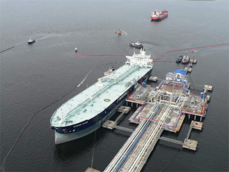
Berths # 1, 2, 3, & 4 (Crude Oil) main restrictions:
Berths 1, 2, 3 – port side alongside; berth 4 – starboard side alongside.
Berths #1 & #2:
- Both T-shape jetty
- Length 375.10 meters
- Depth 17.80 meters
- Each equipped with 5х16” cargo arms (4 for cargo, 1 for vapour) and 1×8” HFO bunkering arm
- Available for vessels with max LOA 307 meters, beam 55 meters
- Maximum sailing draft – 15.85 meters
Main requirements for berthing vessels:
- Max height of vessel’s receiver sluice valves above sea level is 15.75 meters
- Min height of vessel’s receiver sluice valves above sea level is 5.0 meters
- Spacing interval between axis of a vessel’s intake flanges between 1.7 – 3.0 meters
- Manifolds to ship side 3.5 – 5.0 meters
- Diameter of vessel’s intake flanges is 16”
- Thickness of a vessel’s intake flanges not less than 30 mm
- Minimum time required to close stop valves on a tanker cargo line is 25 sec
Berths #3 & #4:
- Both sides L-shape jetty
- Berth # 3 – port side alongside
- Berth # 4 – starboard side alongside
- Length 432.50 meters (berth #3)
- Length 414.75 meters (berth #4)
- Depth 17.8 meters
- Each equipped with 5х16” cargo arms (3 for crude oil, 2 for DO) and 1×8” HFO bunkering arm
- Available for vessels with max LOA 307 meters, beam 55 meters
- Maximum sailing draft – 15.85 meters
Main requirements for berthing vessels to load crude oil:
- Max height of vessel’s receiver sluice valves above sea level is 19.5 meters
- Min height of vessel’s receiver sluice valves above sea level is 4.0 meters
- Spacing interval between axis of a vessel’s intake flanges ranging 1.7 – 3.0 meters
- Manifolds to ship side 3.5 – 5.0 meters
- Diameter of vessel’s intake flanges 16”
- Thickness of a vessel’s intake flanges not less than 30 mm
- Minimum time required to close stop valves on a tanker cargo line is 25 sec
Main requirements for berthing vessels to load diesel oil:
- Max height of vessel’s receiver sluice valves above sea level is 16.25 meters
- Min height of vessel’s receiver sluice valves above sea level is 4.50 meters
- Spacing interval between axis of a vessel’s intake flanges ranging 1.7 – 3.0 meters
- Manifolds to ship side 3.5 – 5.0 meters
- Diameter of vessel’s intake flanges 16”
- Thickness of a vessel’s intake flanges not less than 30 – 36 mm
- Minimum time required to close stop valves on a tanker cargo line is 20 sec
Berths # 8 & 9 (Oil Products):
- Both L-shape jetty
- Berth # 8 – port side alongside
- Berth # 9 – starboard side alongside
Berth # 8:
- Length 353.0 meters
- Depth 14.7 meters
- Equipped with 4×16 inches cargo arms (3 for cargo, 1 for vapour)
- Available for vessels with max LOA 228.0 meters, beam 32.3 meters
- Maximum sailing draft – 13.7 meters
Main requirements for berthing vessels:
- Max height of vessel’s receiver sluice valves above sea level is 18.30 meters
- Min height of vessel’s receiver sluice valves above sea level is 5.25 meters
- Spacing interval between axis of a vessel’s intake flanges ranges 1.7 – 3.0 meters
- Manifolds to ship side 3.30-5.00 meters
- Diameter of vessel’s intake flanges 16”
- Thickness of a vessel’s intake flanges not less than 30 – 36 mm
- Minimum time required to close stop valves on a tanker cargo line is 20 sec
Berth # 9:
- Length 344.38 meters
- Depth 11.8 meters
- Equipped with 3×16 inches cargo arms (2 for cargo, 1 for vapor)
- Available for vessels with max LOA 185.0 meters, beam 32.2 meters
- Maximum sailing draft – 10.8 meters
Main requirements for berthing vessels:
- Max height of vessel’s receiver sluice valves above sea level is 18.30 meters
- Min height of vessel’s receiver sluice valves above sea level is 5.25 meters
- Spacing interval between axis of a vessel’s intake flanges ranges 1.7 – 3.0 meters
- Manifolds to ship side 3.30-5.00 m
- Diameter of vessel’s intake flanges 16”
- Thickness of a vessel’s intake flanges not less than 30 – 36 mm
- Minimum time required to close stop valves on a tanker cargo line is 20 sec
Tide
Tidal variation is virtually zero.
Weather Restrictions
Mooring to the sea port piers is prohibited when:
- South wind’s direction from 140° to 230° at a wind speed exceeding 15 m/sec
- Wind’s direction is 230° – 0° – 140° at a wind speed exceeding 18 m/sec.
Ships’ mooring to berth No 4 is permitted at a wind speed less than 15 m/sec.
Ships’ unmooring from the berths is permitted at a wind speed less than 20 m/sec.
Port is icebound. Restrictions on the ice class are set by the Harbor Master. Navigation every winter depends on forecasted and actual ice conditions.
Working Hours
Primorsk Port operates 24/7 all year round.
Public holidays:
| Jan 1 – 6 and Jan 8 | New Year holidays |
| Jan 7 | Orthodox Christmas |
| Feb 23 | Defender of the Fatherland Day |
| Mar 8 | International Women’s Day |
| May 1 | Spring and Labor Day |
| May 9 | Victory Day |
| Jun 12 | Day of Russia |
| Nov 4 | National Unity Day |
Services
- Bunkering of FO and MGO is possible alongside
- Bunkering at anchorage or inner roads is strictly prohibited
- Supply of fresh water is available
- Crew change is possible, but all crew members need to have valid Russian Visa (except countries with which Russia has a visa free agreement). On-signers have to receive Russian single-entry visa at the country of their residence, off-signers have to receive a transit (exit) Russian visa. Foreign off-signers must leave Russia via Pulkovo international airport only within 24 hours from the moment of disembarking a vessel, no hotel accommodation allowed.
- Provision, stores and repairs are available at Primorsk
- Service of slops removal is not available
Maps
Photos