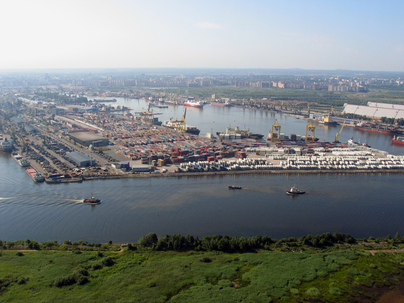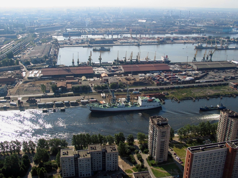

General Description
| UN/LOCODE: | RULED |
| Coordinates: | 59.91933° / 30.327035° |
| B.A. Nautical Chart No: | 2395 & 2264 |
| Admiralty Sailing Directions: | NP20 & NP286 (2) |
| Time zone: | UTC +3 hrs |
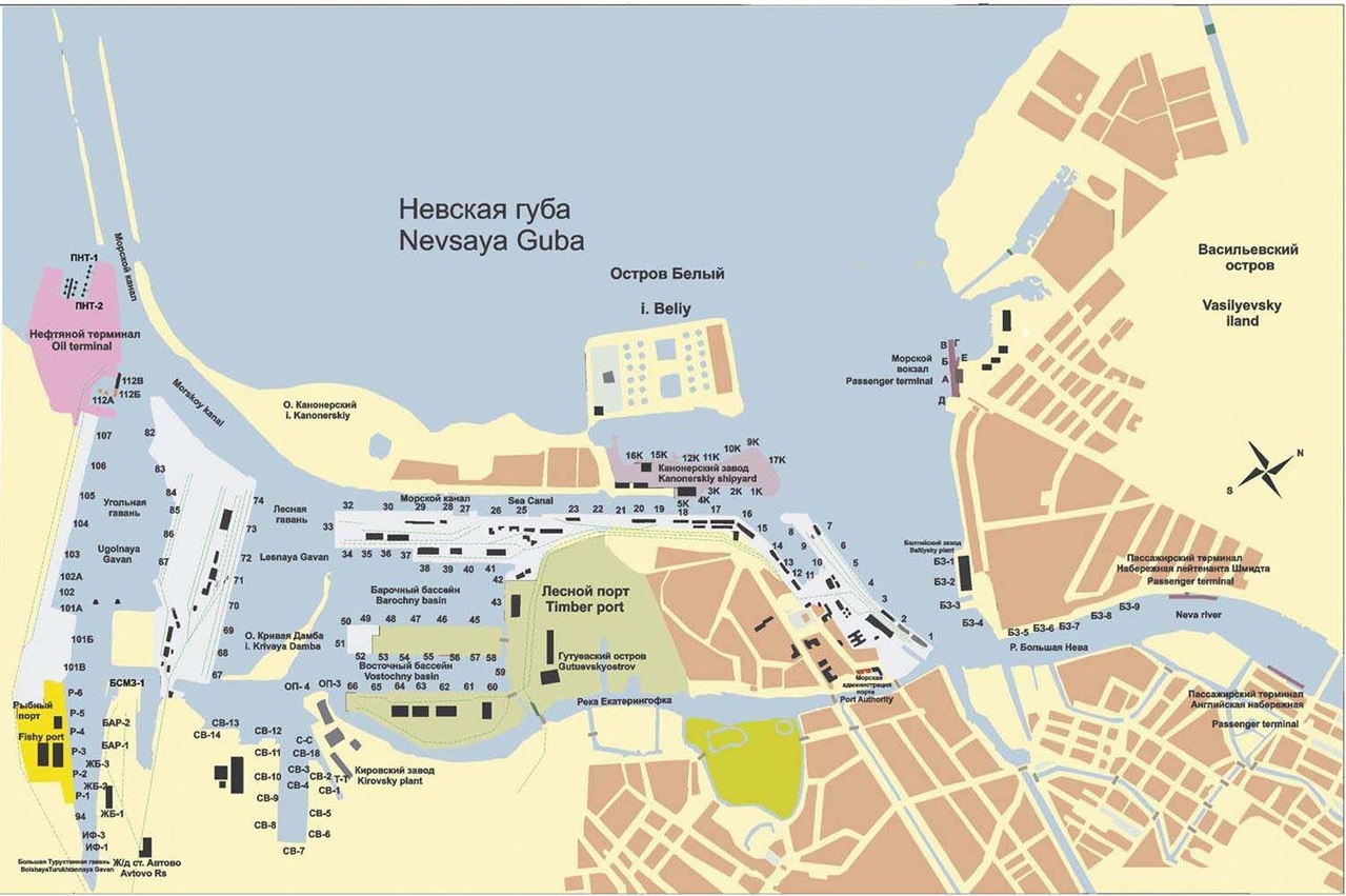
The port comprises of:
- the 1st, 2nd cargo areas in center
- Kanonerskiy shipyard to the north
- Passenger terminal Morskoy Vokzal passenger piers at Lieutenant Schmidt and English Embankments and new passenger terminal Marine Facade to the north-east
- Terminal service and Baltic shipyard to the east
- Petrolesport, North shipyard and Kirovskiy plant to the south
- 3rd area First container terminal and Neva Metall to the west
- 4th area Container Terminal, St. Petersburg and Fishport to the west
- Baltic Bulker terminal and Petersburg Oil terminal to the north-west
Water depth varies between 5.0 and 11.0 meters brackish water and the port has a total of 150 berths.
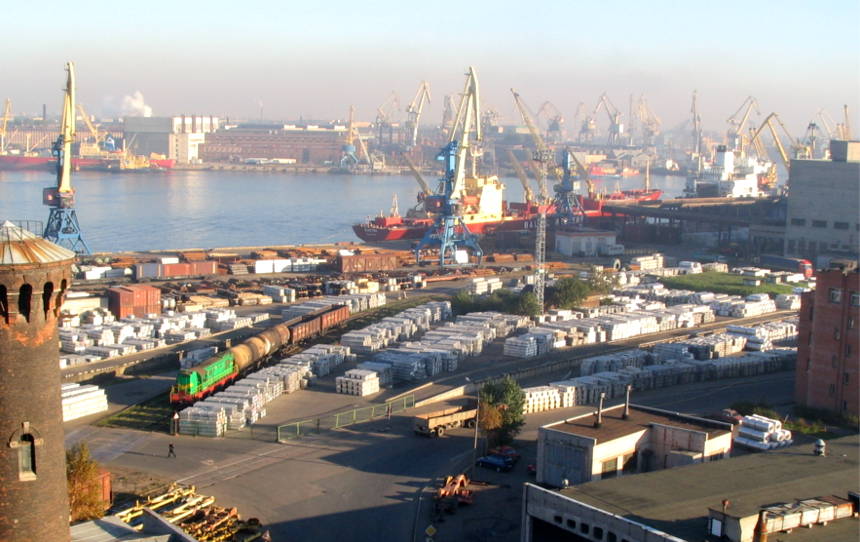
It has specialized terminals for fertilizers, steel cargoes, general cargo, containers, Ro-Ro cargoes, passenger terminals, heavy lift cargoes’ and petroleum products. About 25 stevedoring companies are licensed for cargo operations in the port.
Navigation in the sea port is performed all year round. It has a passenger-and-freight constant multi way checkpoint on the state border of the Russian Federation.
Anchorage Areas
| Outer Anchorage |
| The pilot station is 8 nm westward from Kotlin island.
On the Krasnogorsky roads:
South-Westward of Pesochny Cape:
|
| Inner Anchorage |
Ugolnaya Gavan’ roads
Lesnoy Mole quay roads
Barochny basin roads
Ekateringofsky basin roads
Bolshaya Neva river roads
|
Companies and Terminals
- AO “Sea port St. Petersburg”: 1st cargo area berths № 1-7, 2nd cargo area berths № 15 -41, 3rd cargo area berths № 67-69 (Ferry terminal) except for berth № 27 Baltic Port (owner Zenit) and berths № 28 & № 33 (owner Rosmorport)
- ZAO “Container Terminal St. Petersburg”: berths № 101A, 101B and 101V
- AO “Baltic Bulker Terminal”: berths № 106 and № 107
- OOO “Baltic Port”: berth № 27 (Sea port St. Petersburg)
- AO “Baltic Sudomekh zavod”: berths BSMZ № 1, BSMZ №2 and BSMZ №3
- OOO “Baltimor”: berth LO № 25 port Lomonosov
- OOO “MGS-Terminal”: berth VBI № 1, VBI № 2 and VBI № 3
- OOO “Baltic Fuel Company”: berth SV № 15 and SV №16
- ZAO “Interferrum Metall”: berths IF № 1 and IF №2
- AO “CCTL”: berths SV №1, SV № 2, SV №3 and SV №7
- OOO Mobi Dik (container terminal Kronshtadt): berths №1 and №2
- “Morskoy Vokzal” (AO “PP SPb MF”): berths A, B, V, G, D, E
- OOO Fishport: berths R № 1 – 6
- AO “Neva-Metall”: berths № 71 – 74 (#73 – #74 container terminal)
- AO “First Container Terminal”: berths № 82 – 83 and № 85 – 87
- AO “Petersburg oil Terminal “: berths № 112A, 112B, 112V and PNT № 1 – 4
- AO “Petrolesport”: berths №42, №43, №46 – 50, berths №52 – 58, berths №60 – 64
- OOO Rusmarin: berth SV № 13
- OOO Terminal Sviatogo Petra (St. Petersburg): berths K № 9 – 10, K 15 – 17
- AO “Tetramet”: berth TT №2
- ZAO “Portoflot”: berth №10
- AO “Passenger port Saint-Petersburg “Morskoy Façade”: berths 1-7
- Passenger piers at Lieutenant Schmidt and English Embankments Embankment
Port Restrictions
The sea port of St. Petersburg can accommodate vessels that do not exceed following dimensions:
- Length: 320,0 m
- Breadth: 42,0 m
- Draft: 11,0 m fresh water at the zero level of Kronshtadt tide gauge.
- In case visibility is less than 2 nautical miles, traffic of vessels carrying dangerous goods, except for port bunker supply craft, is prohibited
- Navigation in the sea port is performed all year round
- Traffic of vessels of more than 150 m in length in ballast in the St. Petersburg Morskoy Canal with a side wind speed 10 m and more is prohibited
- All traffic in the port waters shall be stopped when the wind speed reaches 22 m/s, except for fire-fighting and rescue vessels proceeding on permission of the VTS Station
- For purposes of calculation cargo loaded and determination of vessel’s max draft, the density of the water in the port shall be counted as 0,999 very near to fresh water (density 1,0), salinity – about 0,0
- Pilotage for outbound and inbound vessels is performed in convoys twice a day. First starts outbound traffic upon completion followed by inward convoy pilotage. Once a vessel might not be ready for departure/inward maneuvering for any reason by the scheduled time she should stay in her position until the next convoy window is open. Passenger and liner vessels enjoy priority for pilotage convoying. Usual scheduled convoying time local time (subject to weather restrictions):
- 1st outbound convoy to be ready by 00:00 latest every day
- 1st inbound convoy to be ready by 03:00 latest every day
- 2nd outbound convoy to be ready by 12:00 latest every day
- 2nd inbound convoy to be ready by 15:00 latest every day
Tide
In most cases the water level fluctuations depend on prevailing winds and may vary between –1 and +4 meters relative to zero level of Kronshtadt tide gauge.
Weather Restrictions
- Winds of South-West and West directions prevail.
- Restrictions on the ice class are set by a decision of the Harbor Master, depending on ice conditions, increase or decrease of ice class restrictions are set by decision of the Harbor Master.
- Usually ice season commences on 1st of December every year and ends on 30th April, however actual ice situation varies.
- Ice thickness: During heavy winter icebreaker assistance is up to 80-90 cm; Vessels proceed from ice edge to/out port in ice convoys.
Working Hours
Port operates 24/7, including weekends and holidays, with three shifts:
- 1st shift 08:00 – 16:00 lt
- 2nd shift 16:00 – 24:00 lt
- 3rd shift 00:00 – 08:00 lt
Public holidays:
| Jan 1 – 6 and Jan 8 | New Year holidays |
| Jan 7 | Orthodox Christmas |
| Feb 23 | Defender of the Fatherland Day |
| Mar 8 | International Women’s Day |
| May 1 | Labor Day |
| May 9 | Victory Day |
| Jun 12 | Independence Day |
| Nov 4 | National Unity Day |
Port operates during all the public holidays except from 16:00 lt of 31 December until 16:00 lt of 01 January.
Services
- Bunkering: more than 30 bunkering companies work in St. Petersburg while 8 of them have self bunkering barges/fleet
- Fresh Water supply: Delivery mostly by barges. Supply from shore available at berths passenger terminals at plants
- Dry docking & Repairs: There are a number of floating docks, the largest has a lifting capacity of 36,000 dwt. Most hull and machinery repairs can be effected
- Provisions and Stores: All kinds of stores available, no seasonal restrictions
- Medical facilities: Basic facilities in port, several hospitals in the city
- Crew changes: VISA support and crew change available. Most Consuls are represented
- Surveyors: Available
- Garbage/sludge/bilge/sewage waters/used oil removal: covered through environmental dues
- Officials and visitors: possible after immigration/security/pass Depts permission
- Fumigation: Possible
Maps
Photos